
Satellite imagery gives us a comprehensive view of Earth, captured by powerful sensors orbiting high above our heads. But it is much more than a simple picture. Each image is a dense layer of geospatial data, collected through a process called remote sensing. This method allows us to gather information about our world without ever physically touching it.
What Is Satellite Imagery and How Does It Work?
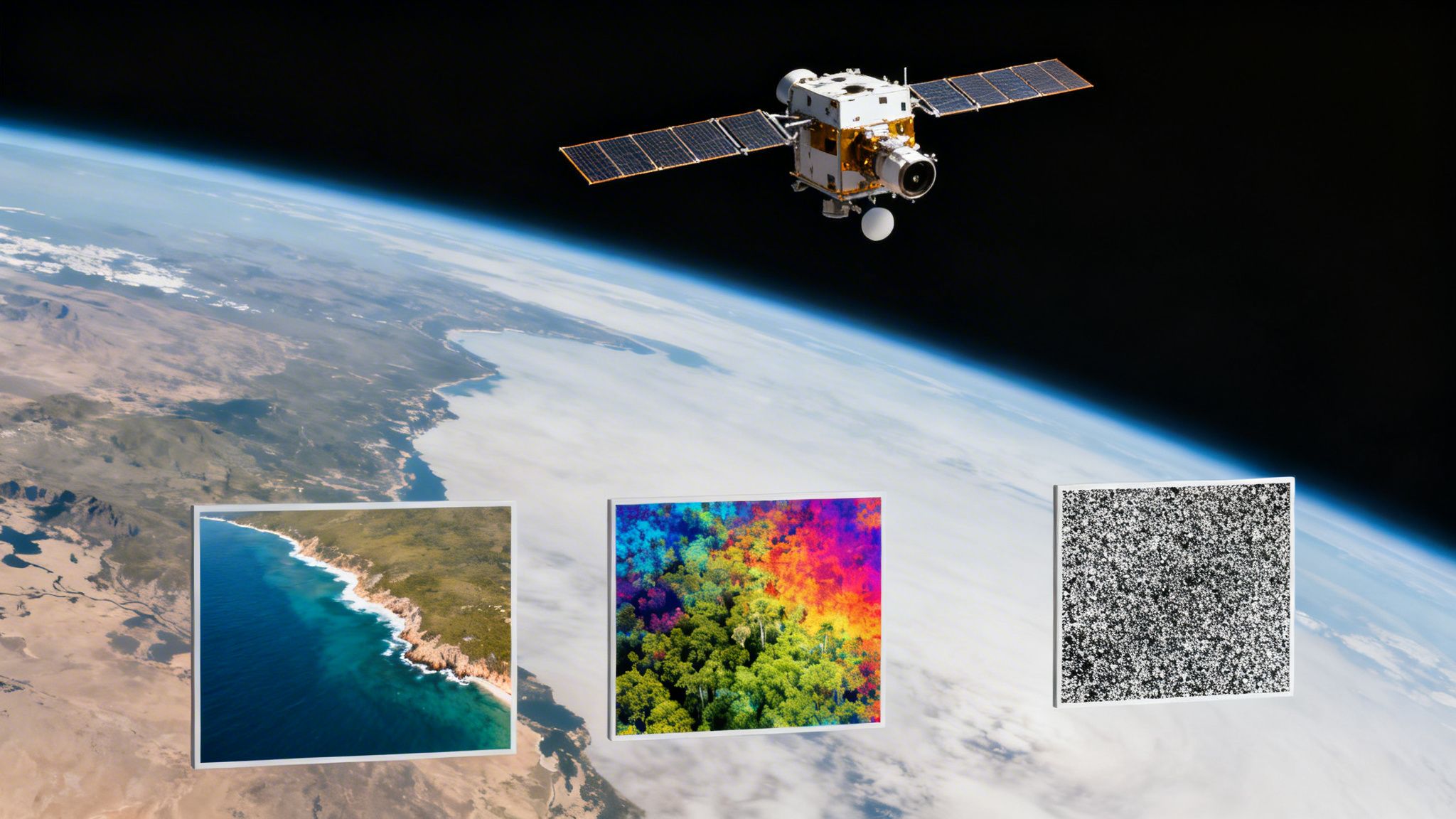
Think of a satellite as a hyper-advanced digital camera in space. Instead of just seeing the world in red, green, and blue like our eyes, its sensors detect a massive range of light, including infrared and ultraviolet wavelengths that are completely invisible to us. That ability to see beyond the visible spectrum is what makes this technology a game changer.
The process starts with a satellite in low Earth orbit, usually somewhere between 160 to 2,000 kilometers up. From there, it captures energy reflecting off the Earth’s surface. Every pixel in the final image is not just a color; it is a precise data point measuring the intensity of reflected light. That raw data is then beamed back to ground stations for processing.
From Raw Pixels to Actionable Intelligence
Once the data is on the ground, it goes through a crucial clean up phase. Technicians run corrections to account for factors like atmospheric haze and the Earth's curvature. This preprocessing step ensures the final image is geographically accurate and ready for analysis.
The result is a clean, detailed map that fuels countless real world applications. For instance:
- Environmental Monitoring: Scientists can track deforestation or monitor crop health by analyzing specific light signatures that show plant stress. This delivers a measurable impact on conservation efforts and food security.
- Urban Planning: City officials can watch urban sprawl happen in near real time, manage large infrastructure projects, and plan for future growth with incredible precision and scalability.
- Defense and Security: Analysts use this data to get a clear picture of what is happening in remote or inaccessible areas, monitoring changes and activities on a global scale with high accuracy.
Ultimately, these images are the raw fuel for powerful AI models. Through expert data annotation, those raw pixels are transformed into structured, labeled datasets. This is what teaches machines to recognize objects and spot patterns, turning a view from space into measurable, on the ground intelligence.
Understanding the Four Pillars of Image Resolution
To truly define satellite imagery, you have to look past the picture itself and dig into the quality of the data behind it. For any AI team trying to turn pixels into actual business intelligence, the value of an image boils down to four distinct types of resolution.
Think of these four pillars as the technical specifications of your window to the world. Each one measures a different aspect of the image’s clarity and detail. Achieving the right combination is critical and depends entirely on your project's objectives.
The Dimensions of Detail
The four core types of resolution work together to determine if an image is useful for a specific job:
Spatial Resolution: This is the most intuitive concept. It is similar to the pixel count on a high definition TV. It measures the size of a single pixel on the ground. Higher spatial resolution means smaller pixels, which allows you to see much more detail, letting an AI model spot smaller objects like individual cars or even trees.
Spectral Resolution: This is about the number of different light bands the satellite’s sensor can detect. A standard camera sees three bands (red, green, and blue), but a multispectral sensor might capture dozens. It’s like giving your AI model a superpower, allowing it to see subtle details invisible to the human eye, like signs of crop stress or specific mineral deposits in the soil.
The flowchart below shows the journey from a satellite capturing raw data to generating actionable insights ready for analysis.
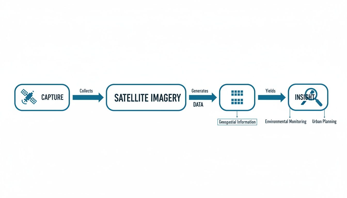
This process is what turns a stream of data from orbit into a structured, valuable asset for scalable AI solutions.
Measuring Time and Sensitivity
Beyond just detail and color, two other resolutions are critical for tracking changes over time and ensuring your data is accurate.
Temporal Resolution: This one is all about frequency. It measures how often a satellite revisits and captures an image of the exact same spot. A high temporal resolution is like having a time lapse camera in space, giving you daily or weekly updates that are perfect for monitoring activities like construction progress or tracking rapid environmental shifts.
Radiometric Resolution: This measures the sensor's sensitivity to tiny differences in brightness or energy. Think of it as the sensor's ability to see more "shades of gray." Higher radiometric resolution is essential for detailed analysis in fields like forestry or oceanography, where distinguishing between very similar surfaces is key.
These four concepts are the foundation for understanding satellite data quality and its impact on AI performance.
A Quick Guide to the Four Types of Resolution
Here's a simple table to summarize how each resolution type contributes to the overall quality and usefulness of satellite imagery for AI applications.
| Resolution Type | What It Measures | Simple Analogy | Importance for AI |
|---|---|---|---|
| Spatial | The size of one pixel on the ground | Pixel count on a TV screen | Essential for detecting small objects and fine details |
| Spectral | Number of light bands captured | A camera that sees more colors than the human eye | Allows AI to identify materials and conditions invisible to us |
| Temporal | How often an image of the same location is taken | A time lapse camera | Crucial for change detection and monitoring trends |
| Radiometric | The sensor's sensitivity to light intensity | The number of shades between black and white | Key for distinguishing subtle differences in surfaces |
Understanding these four pillars is the first step for any team looking to move from simply viewing images to extracting real, quantitative insights from them.
Exploring the Main Types of Satellite Imagery
Not all satellite images are created equal. Depending on the sensors onboard, the data beamed back to Earth can tell vastly different stories about the world below. Picking the right imagery type is the first step in solving a specific problem, whether that is tracking deforestation or assessing insurance claims.
Each category offers a unique lens, bringing distinct advantages to the table. Most modern operations blend these imagery types to build a complete, multi layered view of what is happening on the ground.
Optical Imagery: What the Human Eye Would See
The most familiar type is optical imagery. Think of it as a massive, high powered digital camera orbiting the planet. It captures reflected sunlight in the red, green, and blue (RGB) bands, the same visible light our eyes see, to create natural looking photos.
These images are perfect for tasks where clear visual confirmation is key, like mapping urban sprawl, checking property damage after a hurricane, or simply getting a clean "snapshot" of a location. The major limitation? They need clear skies and daylight. Clouds, smoke, and nighttime render them useless.
Multispectral and Hyperspectral Imagery: Seeing the Invisible
This is where things get interesting. Multispectral and hyperspectral sensors go far beyond what we can see, capturing data across dozens or even hundreds of narrow light bands outside the visible spectrum. This lets analysts detect the unique chemical and physical signatures of objects on the ground.
These advanced sensors are the foundation for countless modern AI applications. A multispectral image, for instance, can spot early signs of crop stress by measuring chlorophyll levels long before a farmer would ever notice the leaves turning yellow. This provides an actionable insight that directly impacts yield and profitability.
Synthetic Aperture Radar: Seeing Through Obstacles
Finally, Synthetic Aperture Radar (SAR) is a true game changer because it does not need the sun at all. Instead of passively collecting reflected light, SAR satellites actively fire microwave pulses at the Earth and measure the signals that bounce back.
This "active sensing" allows SAR to see right through clouds, fog, smoke, and total darkness. It is an indispensable tool for disaster response teams tracking floodwaters beneath thick storm clouds or for maritime agencies monitoring illegal fishing at night. Our approach to perception artificial intelligence often relies on SAR for its around the clock reliability and accuracy.
How Satellite Images Become Actionable Insights
A satellite image is just a collection of pixels until it is put through a rigorous workflow. Turning that raw data from orbit into reliable business intelligence is a journey that ensures every pixel is accurate, corrected, and ready for sophisticated AI analysis.
This entire process breaks down into four essential stages, moving from the moment an image is captured to the final analysis that drives decisions.
The Four Stages of Geospatial Data Transformation
Data Acquisition: It all starts here. Satellites capture raw image data of the Earth’s surface and beam it back to ground stations. This initial data is completely unprocessed and full of distortions that need to be fixed.
Data Preprocessing: Next, the raw data goes through a critical cleanup. This stage removes atmospheric haze, corrects for the planet’s curvature, and pins the image to precise geographic coordinates. Without this step, any measurements would be wildly inaccurate.
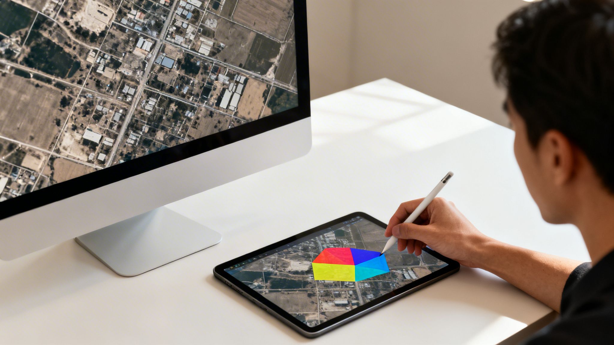
Data Annotation: This is where raw data finally gets its context, thanks to human experts. Analysts meticulously label features in the imagery, identifying buildings, roads, vehicles, or even specific crop types. This process, often using techniques like semantic segmentation, is what teaches an AI model what to look for with high accuracy.
Analysis and Modeling: With precisely labeled data in hand, data scientists can train and deploy computer vision algorithms. A model trained on high quality annotated data can detect patterns, monitor changes, and make predictions at an incredible scale.
The quality of the data annotation stage directly determines how well the final AI model performs. Inaccurate or inconsistent labels lead to unreliable algorithms, making this human led step the absolute bedrock of any successful geospatial AI project.
This structured workflow is the result of decades of remote sensing refinement. Satellite imagery has come a long way since the very first orbital photo was snapped back in 1959. By 1972, the Landsat program kicked off, creating what is now the longest continuous record of our planet from space. You can explore the history of satellite imagery and dive into its five decade archive of planetary data.
How Modern Industries Use Satellite Imagery
Across countless sectors, satellite imagery has moved from a niche technology to a core driver of business strategy. Companies are learning to turn this bird’s eye view into ground level truth, solving complex problems with a scale and accuracy that was once unimaginable. From monitoring global supply chains to assessing local infrastructure, the applications are as diverse as they are powerful.
This modern capability is built on a long history of looking down from space. The journey really began in 1960 when NASA launched Tiros-1, the first true weather satellite. It sent back infrared images of Earth's cloud cover and gave us our first orbital view of hurricanes, proving the immense practical value of having eyes in the sky.
Transforming Operations from Above
The real magic happens when businesses connect satellite data to their specific operational challenges. This technology provides an objective, verifiable record of physical assets and environmental conditions, helping teams cut through uncertainty, reduce risk, and work smarter.
Here are just a few real world use cases demonstrating measurable impact:
- Environmental Monitoring: Conservation groups and government agencies use satellite data to track deforestation almost as it happens, monitor the health of polar ice caps, and manage natural resources more sustainably.
- Precision Agriculture: Farmers analyze multispectral imagery to check crop health acre by acre. This lets them optimize irrigation and apply fertilizers with surgical precision, boosting yields while cutting down on waste and cost.
- Urban Planning: City planners use this data to oversee major infrastructure projects, manage urban sprawl, and spot areas at risk from flooding or other hazards. The result is safer, more resilient cities.
Driving Efficiency and Mitigating Risk
The insurance industry is another field undergoing a massive shift. After a hurricane or wildfire, insurers can use high resolution satellite images to quickly assess property damage across a huge area. This speeds up claim validation and helps them get resources to affected customers faster than ever before. This kind of remote assessment is a cornerstone of modern geospatial and remote sensing strategies.
By turning pixels into actionable intelligence, satellite imagery allows businesses to answer critical questions: Are our assets secure? Are our environmental policies working? How can we respond faster to a crisis? The answers drive smarter decisions, reduce operational costs, and unlock new opportunities.
Unlock Your Geospatial AI Potential
Having access to satellite data is a great start, but it is only the first step. Raw pixels do not create value on their own. Turning that imagery into reliable intelligence requires specialized expertise in data processing and, most importantly, annotation.
Think of it this way: the accuracy of your geospatial algorithms is a direct reflection of the quality of the data they are trained on. This makes the annotation phase the absolute foundation for any team looking to build a competitive edge with AI.
This is where a strategic partnership makes all the difference. We provide the essential services that transform raw satellite imagery into powerful business intelligence. From high accuracy data annotation to scalable quality assurance workflows, our team helps you build dependable geospatial models that deliver a real, measurable impact. Our work in perception artificial intelligence shows just how critical precise labeling is for achieving high performance.
The success of any AI project hinges on the quality of its training data. Without meticulously labeled imagery, even the most advanced models will fail to produce reliable insights, leading to costly errors and missed opportunities.
Let's talk about how our solutions can help you turn raw satellite imagery into a decisive competitive advantage.
Frequently Asked Questions About Satellite Imagery
To wrap things up, let's tackle a few common questions that pop up when teams first start working with satellite imagery.
What Is the Difference Between Satellite and Aerial Imagery?
While both give you a bird's eye view, the real difference is altitude and scale. Satellite imagery is captured from space, anywhere from 160 to 2,000 kilometers up. This massive distance makes it perfect for monitoring huge areas, like tracking deforestation across a continent or watching weather patterns unfold.
Aerial imagery, on the other hand, comes from planes or drones flying much closer to the ground. This low altitude delivers incredible detail and higher spatial resolution, making it the go to for localized tasks. Think inspecting a single building for insurance claims or getting precise measurements for a new construction project.
How Do You Access Satellite Imagery?
You generally have two paths here. First, there are public sources like the U.S. Geological Survey’s Landsat program or the European Space Agency's Sentinel mission. These are amazing resources, offering a treasure trove of historical and current data for free.
For projects needing sharper images or more frequent updates, commercial providers are the answer. They offer premium imagery, on demand tasking for specific locations, and access to more advanced sensor data that can be tailored to your exact business needs.
What Makes Annotating Satellite Images So Challenging?
Labeling satellite images is not like annotating photos of cats and dogs; it comes with a unique set of challenges that require real expertise.
A few of the biggest challenges include:
- Vast Object Scale: How do you consistently label everything from a single car to an entire forest across thousands of images? Maintaining that consistency is a huge lift.
- Atmospheric Distortion: Clouds, haze, fog, and shadows are a constant problem. They can easily hide or alter features, and it takes a trained eye to interpret what is really on the ground.
- Domain Knowledge: You cannot just guess. Identifying specific crop types, subtle geological formations, or different classes of military hardware requires deep subject matter knowledge.
This is exactly why so many teams partner with an experienced annotation provider. Getting the ground truth right is the only way to build an AI model you can actually trust.
Ready to turn raw satellite data into a powerful competitive advantage? Prudent Partners provides the high-accuracy data annotation and quality assurance needed to build dependable geospatial AI models. Connect with us today for a customized solution.