
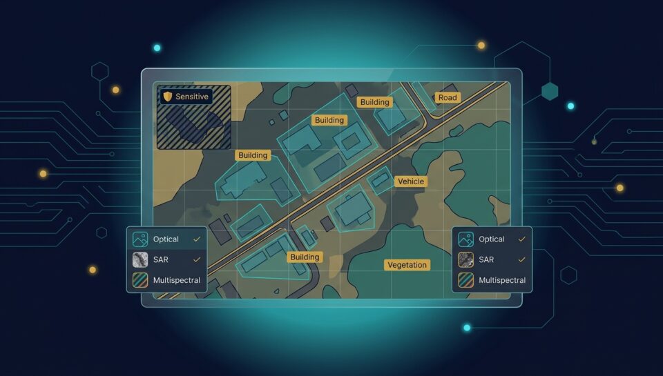
Geospatial AI has moved well beyond mapping. Satellite and aerial imagery now feeds models that detect infrastructure change, monitor environmental conditions, assess damage after events, track development, and support intelligence workflows. These models learn from annotated imagery, and the annotation is unlike most other computer vision work: the objects are small, the imagery is enormous, the context required is specialised, and the data itself frequently carries handling restrictions that shape how the work can be done at all. This guide covers what geospatial intelligence annotation involves and how to evaluate a partner for it.
Why Overhead Imagery Is Different
Scale and object size. A single satellite image can cover hundreds of square kilometres, and the objects of interest may occupy a handful of pixels. Annotators work at extreme zoom across enormous canvases, and the difference between a vehicle and a shadow is genuinely ambiguous at the resolutions involved.
Viewpoint unfamiliarity. Objects from directly overhead look nothing like they do at ground level. This is learnable but not intuitive, and untrained annotators make systematic errors on categories that seem obvious to someone experienced with overhead imagery.
Variable conditions. The same location looks materially different across seasons, times of day, cloud cover, and sensor types. Consistency across those variations is the central quality challenge.
Multi-spectral and non-visual data. Much geospatial work involves bands beyond visible light, or radar imagery where the interpretation rules differ entirely from optical. Annotators need to understand what they are looking at rather than pattern-matching visually.
Temporal sequences. A large share of the value is in change over time, which means annotating pairs or series consistently rather than individual images.
What Gets Annotated
Object detection and counting. Vehicles, aircraft, vessels, structures, and equipment, often at very small pixel sizes.
Segmentation of land cover and use. Delineating built-up areas, vegetation, water, roads, and agricultural land, which underpins most environmental and planning applications.
Change detection. Marking what differs between images of the same location across time, and classifying the change. This is the highest-value and most judgment-intensive category, because deciding what constitutes meaningful change rather than seasonal or sensor variation requires domain understanding.
Infrastructure and feature extraction. Roads, buildings, power infrastructure, and facilities, frequently with attributes rather than just outlines.
Damage and condition assessment. Post-event imagery graded by severity, where consistency across annotators is difficult and consequential.
Ourimage annotation andvideo annotation capabilities cover the underlying techniques, and3D point cloud annotation covers elevation and lidar-derived work.
Sensitive Location Data Changes the Operating Model
This is the dimension that most distinguishes intelligence-adjacent geospatial work from commercial geospatial work.
Imagery of sensitive locations, and derived products from it, frequently carries handling restrictions arising from contract terms, licensing conditions, export considerations, or customer obligations. Those restrictions shape practical questions: who may view the imagery, from which locations, on what infrastructure, and what may be retained after the engagement.
The consequences run through the whole delivery model. Work may need to occur in controlled facilities rather than remotely. Deployment may need to be isolated rather than shared. Personnel screening requirements may be stricter than standard. And the provider needs to be able to describe all of this precisely rather than reassuringly, because a general security posture is not the same as an ability to handle restricted material.
Buyers in this space search for exactly this, partners experienced with geospatial intelligence workflows and cleared to handle sensitive location data, which reflects how much the operating model matters relative to annotation skill alone.
Quality Measurement in Geospatial Work
Measurement is harder here for a specific reason: ground truth is often genuinely uncertain. Whether a small cluster of pixels is a vehicle may not be resolvable from the imagery alone, so disagreement between skilled annotators is not always error.
The practical approach is measuring agreement while accepting that some irreducible disagreement is inherent to the data, and tracking whether disagreement concentrates in particular categories, conditions, or annotators, which distinguishes inherent ambiguity from a guideline or training problem. Ourannotation quality guide covers the method; the interpretation is what differs in this domain.
Geographic and seasonal coverage also matters for the dataset itself. A model trained on imagery from one region and season performs poorly elsewhere, which makes deliberate coverage a quality requirement rather than a nice-to-have.
Evaluating a Geospatial Annotation Partner
Ask about experience with your specific imagery types, including resolution, sensor, and spectral bands, since optical experience does not transfer automatically to radar. Ask how annotators are trained on overhead interpretation specifically. Ask how change detection guidelines distinguish meaningful change from seasonal and sensor variation. Ask precisely how restricted material would be handled, covering facility, infrastructure, personnel, and retention. And ask for a pilot on genuinely difficult imagery rather than clean high-resolution examples. Ourvendor evaluation guide covers the broader procurement discipline.
Common Questions From Geospatial AI Teams
Why is overhead imagery harder to annotate than ground-level imagery?
Objects are extremely small relative to enormous images, the overhead viewpoint is unfamiliar, conditions vary greatly across seasons and sensors, and much of the data is multi-spectral or radar rather than visible light.
What is change detection annotation?
Marking and classifying what differs between images of the same location over time. It is the highest-value and most judgment-intensive category, because distinguishing meaningful change from seasonal or sensor variation requires domain understanding.
Does optical imagery experience transfer to radar?
Not automatically. Radar interpretation follows different rules, so a partner experienced only with optical imagery may make systematic errors on radar data. Ask about the specific sensor types you use.
How does sensitive location data change how the work is done?
It constrains who may view imagery, from where, on what infrastructure, and what may be retained. This can require controlled facilities, isolated deployment, and stricter personnel screening rather than a standard delivery model.
How is quality measured when ground truth is uncertain?
By measuring agreement while accepting some irreducible disagreement inherent to the imagery, and by tracking whether disagreement concentrates in particular categories or conditions, which separates ambiguity from a guideline problem.
Why does geographic coverage matter in the dataset?
Because a model trained on one region and season performs poorly elsewhere. Deliberate coverage across geographies and conditions is a quality requirement rather than an optional extra.
What should a pilot cover for geospatial work?
Genuinely difficult imagery: low resolution, poor conditions, ambiguous objects, and change detection pairs, rather than clean high-resolution examples that do not predict production performance.
What should I ask about handling restricted imagery?
Ask for specifics on facility, infrastructure, personnel screening, and retention, rather than a general security assurance. A strong general posture is not the same as demonstrated ability to handle restricted material.
Working With Prudent Partners
Prudent Partners Private Limited provides geospatial imagery annotation for US teams across object detection, land cover segmentation, change detection, and feature extraction, with annotators trained specifically on overhead interpretation and quality measurement adapted to the ambiguity inherent in the imagery. Handling arrangements for restricted material are specified explicitly rather than assumed. See ourimage annotation capability.
The first conversation is a 30-minute scoping call about your imagery, your use case, and any handling requirements attached to the data. No commitment to go further.